
PROJECTS
Our work centres around a number of projects that are crucial for the foundations of our goals
Featured Project
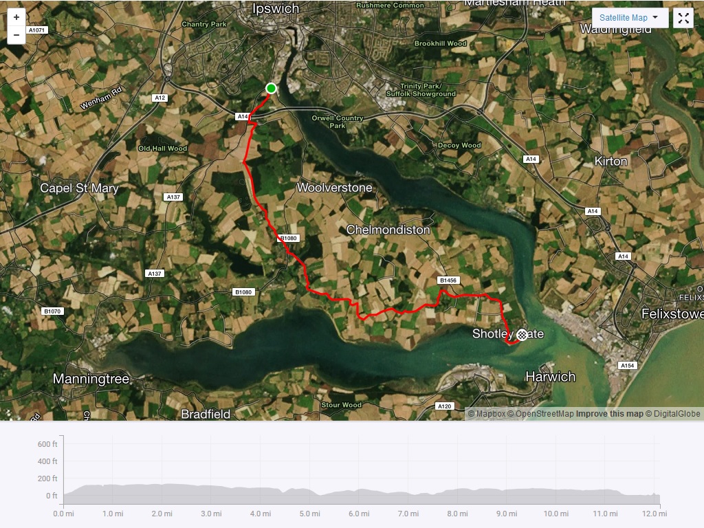
The Shotley Peninsula Green Way
A Community Path
In 2011 we raised enough money to commission Suffolk County Council to carry out a feasibility study into this project. We received generous grants from virtually all the Parish Councils along the route, and several other local organisations (see list below). We published the study for discussion and consultation later that year. It contained a draft route for the community path, together with phasing, costing and funding proposals.
- A new, largely traffic-free, community path from the edge of Ipswich down to Shotley Gate
- Preferred route but with alternative routes over several sections
- About 7.5 miles on new surfaced cycle/footpath
- The route comprises a mix of new path, bridleways, upgraded existing paths and a few on-road sections where no alternative exists
Since publishing this feasibility study and draft route in 2011, and following consultations and discussions, it has become apparent that some changes will be needed. This will normally be to secure landowner agreement or address conservation issues. We will be working out the detailed, final, route as we deal with each section of the path in turn and after securing agreement from the affected landowners.
Initially we are concentrating on the Bourne Bridge to Freston Boot and the Shotley Street to Shotley Gate (foot ferry) sections. As each section is progressed there will be further public consultation which will, in most instances, include the submission of a planning application.
However if you wish to know what the latest thinking is on the proposed alignment of any section of the path, then do contact a member of our committee (see “About Us“)
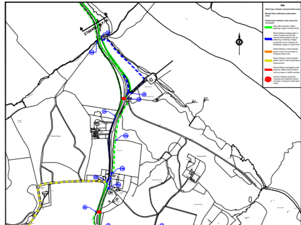
A pictorial view of the proposed route for the path between Erwarton Walk and Shotley Gate can be viewed via Flickr using the links below. Please use the “show info” link on Flickr to get description and information on “map points”.
Erwarton Walk to Shotley Gate section
Bourne Bridge to Freston section
Cycling Survey
In order to collect the information we need about the demand for a safe cycle path network on the Shotley Peninsula we conducted 8 days of traffic and cycle surveys on the B1456 in August and September 2011. These included a count of those cycling along this road as well as all the different types of vehicles using it. These survey results and conclusions can be seen on the links below. The SPCC Committee would like to thank all those (over 20) who volunteered to help out with these surveys.
Also in 2011 we completed a cycling habit survey by asking people to complete a questionnaire. A total of 309 completed questionnaires were returned, 215 from the general public and 94 from Holbrook High School students
These results have now been collected and analysed and they are available to view in the pdf document opposite.
Since publishing this feasibility study and draft route in 2011, and following consultations and discussions, it has become apparent that some changes will be needed. This will normally be to secure landowner agreement or address conservation issues. We will be working out the detailed, final, route as we deal with each section of the path in turn and after securing agreement from the affected landowners.
Initially we are concentrating on the Bourne Bridge to Freston Boot and the Shotley Street to Shotley Gate (foot ferry) sections. As each section is progressed there will be further public consultation which will, in most instances, include the submission of a planning application.
However if you wish to know what the latest thinking is on the proposed alignment of any section of the path, then do contact a member of our committee (see “About Us“)
A pictorial view of the proposed route for the path between Erwarton Walk and Shotley Gate can be viewed via Flickr using the links below. Please use the “show info” link on Flickr to get description and information on “map points”.
Erwarton Walk to Shotley Gate section
Bourne Bridge to Freston section
Sustrans Research
Armed with these survey results we have also commissioned Sustrans, the country’s leading cycling charity, to prepare a report estimating how much annual cycling there is on the B.1456 (2011) and how much this is likely to increase following the introduction of our planned traffic-free community path. Based on similar case studies from other parts of the country Sustrans’ conclusion is that the amount of cycling along the B1456 corridor is likely to double following the construction of this new path. The full report can be viewed here.
Sustrans Report – January 2012
Full list of grant providers:
- Babergh District Council; Babergh East Local Strategic Partnership
- County Councillor David Wood; East of England Co-operative Society
- Ipswich High School for Girls
- The Parish Councils of Chelmondiston, Freston, Holbrook, Shotley, Woolverstone Suffolk Foundation (Greenest County Fund)
Further Projects
The Freston Hill Project
The Southern Route Project
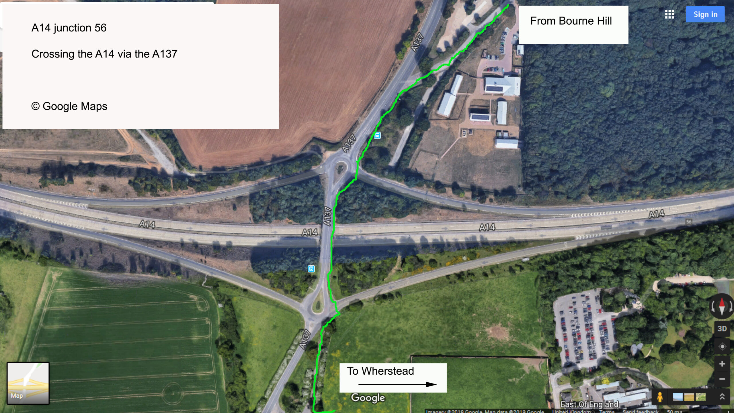
We are proposing a southern route onto the Shotley peninsula as well, although this is currently being thwarted by a poor surface through Cutlers Wood in Freston which carries an SSSI rating . This page details some maps and diagrams:
Ipswich cycle map (part of) and showing suggested walk section.
A14 junction 56 crossing via A137
A14 junction 56 crossing – Google Earth
A14 junction 56 – Google Map Link
Further Projects
The Freston Hill Project
The Southern Route Project
We are proposing a southern route onto the Shotley peninsula as well, although this is currently being thwarted by a poor surface through Cutlers Wood in Freston which carries an SSSI rating . This page details some maps and diagrams:
Ipswich cycle map (part of) and showing suggested walk section.
A14 junction 56 crossing via A137
A14 junction 56 crossing – Google Earth
A14 junction 56 – Google Map Link
Membership
By joining the SPCC membership list you will be helping us to become a stronger voice. With numbers behind us we have a greater chance of pushing through positive changes to the travel infrastructure on the peninsula.
It’s easy to join and membership is completely FREE!
BECOME A MEMBER
- Required Fields